Motorcycle Rides in the Mountain Highlands
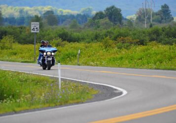
May 19, 2019Call Tucker County home base for daily motorcycle excursions through the heart of West Virginia’s Allegheny Mountains. We have established four individual days’ worth of touring from the greater Canaan Valley/Blackwater Falls lodging area. All roads are paved, 2 lane, lined roadways with the exception of Rt. 48 four-lane highway, which is rarely used. Cell phone service is extremely spotty throughout the mountain highlands, be prepared for no service areas. GPS is discouraged because the shortest route delivered can often be a dirt road. Free West Virginia road maps are available at our Davis, WV Information Center. Open 9am-5pm seven days a week.

Allegheny Highlands
Ride through the highest elevations of West Virginia. The Allegheny Mountains provide a dramatic back drop in West Virginias’ big sky country.
Trip Time: 4hr 50min Mileage: 220
- From the town of Davis, WV head east on Rt.48 to the Rt.93/42 exit for Scherr, WV.
- Continue on Rt.93/42 south to Petersburg, WV, pick up Rt.220 S. in Petersburgh, WV.
- Take Rt.220 south to Franklin, WV and the Rt.33 intersection. Head west on Rt.33.
- Stay on Rt.33 W for 10 miles until the Rt.28 south, junction. Hang a left onto Rt.28 S.
- Continue on Rt.28 S. for Green Bank, WV and Rt.66 west intersection to Cass, WV.
- Take Rt.66W over Cheat Mtn. to Rt. 219 T-intersection.
- Turn right onto Rt.219 north. Head to Elkins,WV and Rt.33 intersection within town limits.
- Turn Right onto Rt.33 east for Harman, WV and Rt.32 north back to Canaan Valley.
- Merge Left onto Rt.32 N in Harman, WV. Canaan Valley is 15mi and Davis 25mi from Harman.
Interesting Fact: Green Bank is home to the largest radio telescope in the world, and for this reason, cell service does not exist for much of the ride. Be prepared.
Mountain Highlands Grand Tour

This is the premier mountain ride through what West Virginian’s refer to as “almost heaven”. Be prepared for a long day in the saddle and endless country roads.
Trip Time: 6hr 50min Mileage: 307
- From Davis, WV take Rt.32 north to Thomas, WV and Rt.219 south.
- Take Rt.219 S. to Montrose, WV and Rt.48/33 west turn off.
- Ride Rt.48/33 W. to Buckhannon, WV and the Rt.20 south exit.
- Take Rt.20 S. to Fenwick, WV and intersection for Rt.39 east to Richwood, WV.
- Take a left onto Rt.39 E. Continue 26 miles until reaching Rt.150 (WV Scenic Highway).
- Take Rt.150 until reaching Rt.219 intersection.
- Take a right onto Rt.219 S. for Marlinton, WV and Rt. 39 east to Huntersville, WV.
- Take a left onto Rt.39 east for 8 miles. Looking for Rt.28 north.
- Take Rt.28 north to Seneca Rocks, WV. In Seneca Rocks you will pick up Rt.33 west.
- Left onto Rt.33 W. for Harman, WV and Rt.32 north.
- Merge right onto Rt.32 N. for Canaan Valley and Davis, WV.
Valleys of the Cheat

Winding valleys and steep ridgetops form the tributaries of the Cheat River. This compact ride has a lot of options to shorten or lengthen the suggested trip.
Trip Time: 5hr 45min Mileage: 188
- From Canaan Valley/Davis/Thomas take Rt. 32/219 north to Oakland, MD.
- From Oakland, MD take Rt. 39/7 west to Camp Dawson, WV and Rt.72 S.
- Left onto Rt. 72 south until reaching US Rt.50.
- Take Rt.50 west (right) approx. 10 miles and turn right on Rt.26 N, until reaching Kingwood, WV.
- From Kingwood take Rt.7 west to Reedsville, WV and Rt.92 intersection.
- Bear left onto Rt.92 south and continue until US Rt.50.
- Take US Rt. 50 west to Grafton, WV
- In Grafton, WV, follow signs for Rt.119 south to Phillipi, WV. Phillipi is rich in Civil War History.
- Pick up Rt.38 east in Phillipi to begin the ride home.
- Continue on Rt.38 E until reaching Rt. 72 T-intersection.
- Left onto Rt.72N until reaching the US Rt.50 intersection.
- Right onto US Rt.50 east; until Rt.24 and Eglon, WV (approx. 15 miles)
- Take Rt.24 south until merging with Rt.219 south. Bear right driving 15 miles until Davis, WV on 219/32 S.
Interesting Fact: The Cheat River and its entire river system flow north until reaching the Ohio River near Pittsburgh, Pennsylvania. Rivers that flow north, like the Nile in Africa, are some of the oldest rivers in the world.
Potomac Highlands

Mountains are what West Virginia is known for. The Potomac River drainage has an entirely different look and feel than the rest of the mountain state.
Trip Time: 4hr 40min Mileage: 220
- Start by heading south on Rt. 32 from Davis/Canaan Valley for Harman, WV and Rt.33 east.
- Bare left in Harman, WV onto Rt.33 east for Seneca Rocks, WV and Rt.28 intersection.
- Left onto Rt.28 north to Moorefield, WV and Rt.48/55 east highway ramp.
- From Moorefield, WV take Rt.48/55 E. to Wardensville, WV and Rt.259 north.
- Take Rt.259 N. from Wardensville until the T-intersection with US Rt. 50 W.
- Left onto US Rt.50 west for 55.4 miles to Skyline, WV and Rt.42 turn-off.
- Take a right onto Rt.42/38 north toward Elk Garden, MD and Rt. 135.
- Left onto Rt. 135 west toward Oakland, MD. and Rt.560 south.
- Left onto Rt.560 S. to Gormania, WV and Rt.90 west.
- Right onto Rt.90 west. Head to Rt.219 south intersection and Thomas, WV.
- Once in Thomas, WV continue on Rt.32 south for Davis, WV and Canaan Valley.

 array(0) {
}